Category: Tech Analysis | Reading Time: 9 Minutes
Using urban exploration 3D scanning technology allows us to freeze a decaying building in perfect digital amber. When you walk through a forgotten asylum or an empty factory, you are witnessing a temporary state of decay. The roof will eventually cave in and the brick walls will inevitably crumble to dust.
This technical analysis explores how modern documentarians are using advanced sensors and complex mathematics to create exact digital replicas of these doomed structures. We will dive into the differences between capturing flat photographs and capturing actual geometric depth, ensuring these historic locations survive forever in the virtual world.
1. The Science of Architectural Photogrammetry
The most accessible form of urban exploration 3D scanning is a process called photogrammetry. This technique does not require specialized laser equipment. Instead, it relies on capturing hundreds or even thousands of overlapping high resolution photographs of a single room.
You must slowly walk around an abandoned space and take pictures from every conceivable angle. Specialized desktop software then analyzes these flat images and looks for matching pixels. By calculating the slight differences in perspective between each photograph, the software can triangulate the exact physical location of every single brick and peeling piece of paint. It then generates a dense point cloud and wraps it in a photorealistic texture. If you want to capture the exterior of a massive asylum, you must pair your ground level photography with aerial images. Flying a camera drone in precise grid patterns over the collapsing roof allows the software to stitch the top of the building seamlessly with the interior rooms you captured on foot.
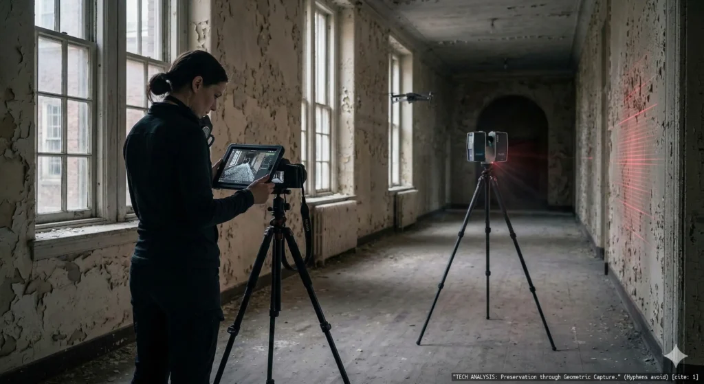
2. LiDAR and Active Laser Mapping
While taking overlapping photos is highly effective, it struggles heavily in the dark and dingy environments typical of decaying architecture. This is where LiDAR technology becomes an absolute necessity for the serious archivist.
LiDAR stands for Light Detection and Ranging. These sophisticated sensors emit millions of invisible laser pulses every single second. When these light pulses hit a rusty boiler or a concrete pillar, they bounce back to the sensor. By measuring the exact time it takes for the light to return, the scanner builds a flawless three dimensional map of the room in real time. Because LiDAR generates its own light, it can accurately map a pitch black basement where traditional cameras would completely fail. In recent years, basic versions of this technology have even been integrated into premium smartphones and tablet devices. While these consumer grade sensors lack the extreme range of professional surveying equipment, they are incredibly useful for scanning small individual artifacts or tight hallways.
3. Processing Massive Data Sets
Capturing the geometric data is only the very first step in the entire process. The real challenge of urban exploration 3D scanning begins when you return to your computer. Generating a highly detailed digital replica requires a massive amount of computational power.
You cannot process these enormous files on a standard budget laptop. You need a dedicated workstation equipped with a high end graphics processing unit and at least sixty four gigabytes of system memory. The software must calculate billions of geometric intersections to build the final mesh. For a massive factory floor, this rendering process can take several days of continuous uninterrupted computing. Furthermore, the sheer size of the raw data files is staggering. A single thorough scan of an old hospital wing can easily consume several terabytes of solid state storage space. You must invest heavily in redundant external hard drives to ensure your irreplaceable digital history is securely backed up.
4. Lighting Challenges and Texture Projection
One of the most difficult technical hurdles is capturing accurate color data to lay over your geometric mesh. If you scan a room with a harsh flashlight, your final digital model will have permanent ugly shadows baked right into the texture walls.
To achieve professional results, you must use highly diffused ambient light or shoot on a heavily overcast day. This ensures the lighting is completely flat and even across the entire structure. Once the geometry is built, the software projects your flat photographs onto the three dimensional shape, creating a flawless virtual replica that looks exactly like the real physical location without any distracting artificial shadows.
5. The Ultimate Form of Preservation
Creating these complex digital models is the absolute peak of historical preservation. When a historic textile mill is finally demolished to make way for a modern parking lot, the physical structure is gone forever.
However, if an archivist has completed a comprehensive scan, the building lives on indefinitely. Researchers and historians can explore the virtual space using virtual reality headsets, walking down the digital corridors just as they existed on the day the scan was completed. It transforms a temporary ruin into a permanent interactive museum exhibit accessible to anyone in the world.
Conclusion
The transition from traditional photography to full geometric scanning represents the future of structural documentation. While the hardware is expensive and the learning curve is exceptionally steep, the ability to build an immortal digital twin of a dying building is an unparalleled achievement in the field of historical preservation.
Over to you: Have you ever used the LiDAR scanner built into your smartphone to map an object or a room? Share your experiences with 3D scanning technology in the comments below!